به منظور درک بهتر جغرافیای منطقه و راه های رسیدن به جاذبه های گردشگری تا جای ممکن مسیر ها توسط جی پی اس ثبت و پس از ویرایش و تصحیح و اضافه کردن نقاط مهم مسیر(به منظور درک بهتر جغرافیای منطقه و راه های رسیدن به جاذبه های گردشگری تا جای ممکن مسیر ها توسط جی پی اس ثبت و پس از ویرایش و تصحیح و اضافه کردن نقاط مهم مسیر) For nature enthusiasts and tourism in one of the most relevant websites wikiloc Placed.

www.wikiloc.com
How wikikoc download files from our gps?
To download files from wikiloc must be registered on this site and create an account. After joining the desired track by selecting the Download link at the top of it there.
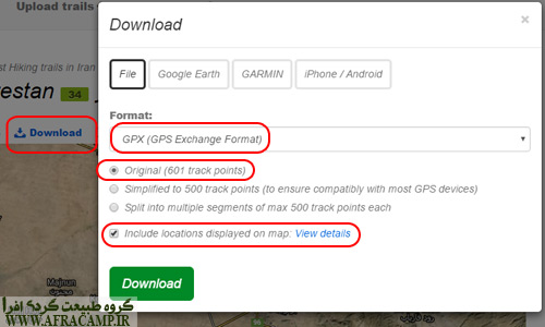
Download any file path that is at the top of this page appears, click on it.
When downloading the cases marked carefully. Burning files to mobile device or gpx format used to more accurately select origin and for that waypoint files also have the file, or choose the last option include location.
How to use the gps file?
If the computer you only need to study the route on google earth download version and then download those files into the software set to open. Then the default route will be able to be traced and the check Terrain. Also able to see information by right-clicking it'll be like height and speed step.
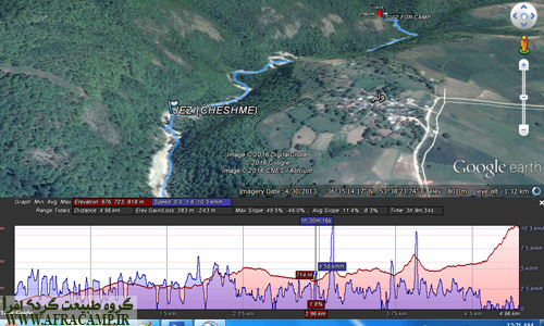
View from the software google earth
With a gps device or even a smart phone smart phone will be able to file with the extension gpx. * View and track your route.
If you like the Garmin Handheld GPS device you use, you need to use software to map source files transfer device.
If you have a smartphone with an operating system ios or android breaking, innovative software applications to open the files there gpx. After opening the file with the relevant Application and enable gps phone can follow the path.
GPS files are important because if you do not have a path guide, you will follow the so-called file by relying on the registered path and placing yourself in the registered points, and finally you will reach your destination..
The markup in the gps file is very important
Sometimes it is difficult to find a way with a route line, because due to the error of recording points in practice, even though you are on the route, you may face challenges in nature.. In these cases, important markings help and the right path can be found.
You also record your route
Route registration is important in several ways. If you have lost your way, you can return to your own path. If you need to study your route later, you can use your route file. Maybe one day you shared this path and left no one on the road. Be sure to mark important points such as springs, precipices, intersections. It does not matter if you are using a mobile phone or a GPS device. With both, the path can be registered and the necessary edits can be made on the computer with software such as map source.
Maple Group recorded routes in wikiloc
This will be completed ...

Hi
Thank you for your site and team spirit at least to me, incentive travel and ecotourism in construction
But it's a question about software wikiloc or similar; the main problem is that in nature we lay out directions, every moment where I tell you that you are leaving. There is a problem using wikiloc is impossible to use the live tracking, maybe I could not active
There are good routes and accurate on the Internet, but when you're on that path, and generally do not have access to Ayntnrnt, how to make you understand that the chosen path is right or not?
Thank you very much
Hello and thank you for Ltftvn
To use the file must travel before starting the download files and accurately in the Google Earth Chkshvn. After ensuring that Mnasbh file transfer to your smartphone or GPS device.
برای کار با اپلیکیشن ویکی لوک با توجه به اینکه دانلود مستقیم مسیر با خود اپلیکیشن پولیه، بهتره ابتدا از وب سایت فایل رو روی گوشی ذخیره کنید و با اجرای اون فایل مستقیم میره در اپلیکیشن ویکی لوک و شما در هر زمانی می تونید اون رو ترک and always keep on track and to work offline. To download files, you must register two Luke Wiki.
Good luck.
Best Regards
Wikilook is one of the best popular software and there is no doubt!
The Live Trekking option is for the premium or paid version, you have to pay a dollar to activate it for you
However, with all the free features available, Mizareh is great without a doubt!
Thank you very much for your answer and ashamed that I did not fully understand
For example, I crack the code "of city management and Meshkinshar up .." You got that this is: 13748910 enter my apps. نقشه رو به همراه پروفایل شما و بقیه مشخصات میاره ولی وقتی گزینه download and follow رو می زنم یه صفحه ای باز می شه که نوشته get your navigation pack now و بعد هم یک ارور از خود اپلیکیشن میاد که :
Error: problem setting up in-app billing: labResult: Error checking for billing V3 Support
And have no choice but ok that after he was left out
You had encountered such a problem?
PLEASE. The task is exactly the same problem, I can not download apps, but not directly from the site to download and import.
When downloading the features I listed above Make sure to follow. Origin and include …
Thank you, my problem was solved with nice tips
Really help you
Doc was right Dvstmvn
I just add that
If you Faylsh Android open Nshd, the following form you automatically open the application ESexplorer
Select the check after the open as the first Faylsh
Then showed his phone apps you select wikiloc
Hi, I have been looking for such a program for a long time and I found it, but I have a few questions.
First, WikiLock is version 3 and has no follow option
Secondly, when I opened a crack, I went out of the program in the national area, I could not follow it, and it did not show the neighborhoods accurately and precisely.
Third, where to download the exact cracks
Thank you for your help
Peace be upon you and ashamed of the delay in reply.
Unfortunately, the WikiLeak app is no longer free and you can not use it to follow. But…
– You can still track your route with this app.
– If there is a path you want to follow, download it from the web and open it in other applications. For iOS, the trackviewer application is a suitable app.. For Android, there are such applications that you can only follow the path..
Download Nmyknh.fkr I Polje!!!
Whether on Luke wiki created membership accounts? You must be registered to download for free directly from the Download. You can download the application not.
To send files, gps
Including incomplete Posted
Gps file record Vdanlvd recorded files
Gps file record ,Vaplvd of these programs and use of recorded routes on swine Luke
Hi
What kind of Maps.me I run the downloaded file?
Hi. You must use software such as GPX Viewer.
Hello, very nice site thanks and appreciation for the mess we Zhmthayy. I had a question, for what we IOS? After you've downloaded the file on the phone that I can show you how to move the phone and open it?
Peace be upon you, thank Ltftvn. For iPhone is certainly appropriate software to read the files there but you have to look so I can introduce my gps
Download the file via safrai. After downloading the appropriate application that reads the track, select it to be imported. track viewer is a good application.
I've downloaded the site's map of Mount Sahand
I came to you now open software
Put files for complete and accurate
May I tell him to leave his options followtarial after a bad money
Why not approach this?
I think if the old version Wikiloc Application install problem was solved.
Hi way to open files with the extension gps map * there?
Slam.ltfa method to import the file to watch the Phoenix Garmin explanation Thank Bdhyd.khyly
Peace be upon you, has had with this device did not work. It's a good idea to use your own guide and see what the mapsource identifies your device under. A typical GPS device?
Hi, when I am recording a record, it warns me from somewhere that there is no GP signal and it is not possible to record a trailer. What do you think I should do? I feel the problem is with the settings of my phone and my Huawei phone
Hi, this error is normal when the signal is lost. Otherwise it is not normal.
If the phone is on flight mode and the GPS settings of the phone should be set to the device only, the problem should be solved!
Hi, I installed the old version of WikiLook on the Xiaomi Note 8 Pro phone. The map of Iran will be downloaded, but the map will not run.
For iOS, use the GPS tracker software that has a yellow icon. I tested it, it works well
Hi
Your explanations and guidance are very useful
I wanted to ask if WikiLook needs updating and how to update
Peace be upon you. Update to do well, but I explained in the comment that you can not follow the path with WikiLook, unfortunately.
Hi, thank you for your useful information
I had two questions:
1. How to edit tracks registered in Wikilook? Removed and corrected incorrect paths?
2. In a saved file, how can we find the times of the route's failure?
Thank you
Greetings to you Mr. Bayat,
Thank you.
Regarding the first question: After downloading the track from the Wikiloc site or any other reference, this can be done using editing software. I usually use MapSource_6163 software. When you open the file in this software. You will be able to remove or add way-points and draw or remove sections of the route with special tools.
Regarding the second question: I assume you mean the time of recording the points? If this is. When you open the track in the mentioned software, all the points, recording time, coordinates, and height can be seen in the properties of the route as the features of the captured point..